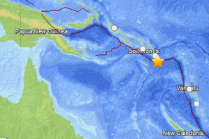
Solomon Islands Hit By 7.6 Magnitude Earthquake; Tsunami Warning Cancelled
Solomon Islands Hit By 7.6 Mag Earthquake

Natural Life Energy
The Solomon Islands were hit by a 7.6 magnitude earthquake awakening residents of the islands around 7:14am Sunday morning local time.
The knowledge of the powerful earthquake set off concerns about a tsunami that could follow.
A tsunami warning was issued Sunday for some Pacific islands following the powerful 7.6 magnitude earthquake near the Solomon Islands, which is about 1,000 miles northeast of Australia.
The United States Geological Service indicated the epicenter of the 7.6 magnitude earthquake was 18.2 miles deep and 200 miles southeast of Honiara, the Solomon Islands’ capital.
The 7.6 magnitude earthquake resulted in tsunami warnings being issued for the Solomon Islands, Vanuatu, New Calendonia, and Papua New Guinea, which has now been cancelled.
A Tsunami watch was in effect for Figi, Australia, Indonesia, Guam, and nearby areas.
Presently there are no reports of serious injury or deaths as a result of the 7.6 magnitude earthquake.
U.S. officials said there is no tsunami threats to Hawaii, Alaska, or the west of of the United States.
The area around the Solomon Islands is often hit by earthquakes and the area is known as the “Ring of Fire.” The 7.6 magnitude earthquake is one of many earthquakes and volcanic activity that happens in the area and stretches around the Pacific Rim.
The Solomon Islands lie near the area where the Australia plate and the Pacific plates converge.
The action of the convergence and slipping of these underwater plates past each other caused this 7.6 magnitude earthquake that hit the Solomon Islands, and is responsible for the earthquakes and volcanic activity the frequent the area.
“The region of the April 12 earthquake is very seismically active, with 27 earthquakes of M6+ occurring within 100 km and 62 events of M7+ within 500 km since 1900.”
Sources
M7.6 – 100km SSE of Kirakira, Solomon Islands


